
|
At the time of writing this has been the most convectively quiet Spring and Summer I can ever remember. June goes down in my own personal records as the most uneventful I have ever experienced, there was no convection or storm outlooks at all for the entire month which is quite unusual. However I wasn't complaining too much for we have been treated to weeks of settled high pressure weather with very little in the way of rain, it had been dry and calm for a long time and with a respectable amount of warm sunny days which I have enjoyed. However there's only so much one can take before wanting a good Summer thunderstorm.
Enter July and suddenly things change and the models presented us with our first set-up for a very long time. The target day was July 4th when GFS produced 1000 j/kg of CAPE however 24 hours before chase day the energy changed to 600 j/kg which is still respectable and in all likelihood the true amount of instability was likely greater than this, and in retrospect it must have been. This would be a slack Sly flow with -30C air aloft however there were concerns about cloud cover. For 48 hours before target day N. Ireland has been covered in relentless low grey cloud which never broke causing temperatures to drop and in places to the north this had produced mist and fog, even inland was thick grey haze and the sun couldn't be seen it all. The Met Office site showed this cloud to remain on July 4th so if true we would not be getting any solar heating and visibility would be terrible even if storms did form. The other negative was the complete lack of wind shear so storms would be messy and of the pulse type and in all likelihood would lack any decent structure. At this stage I already had the day wrote off as a complete let down with cool grey skies and nothing worth looking at. However, I was going to chase anyway, it had been so long that I just wanted to see a convective cloud again, I would take anything nature presented me with.
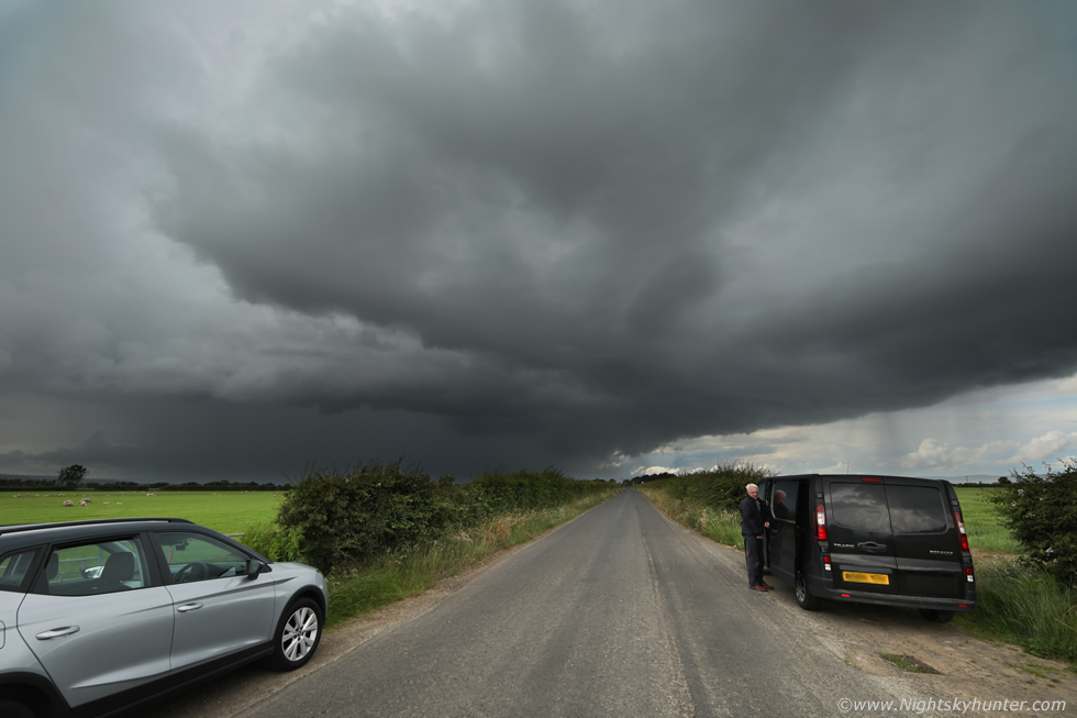
On the morning of July 4th I was up early and prepping the van with water and all my camera gear and waterproof clothing incase we needed it. Roisin would be chasing with me too which was great because she hadn't been out with me looking for storms in such a long time. Roisin made us sandwiches and snacks then we grabbed our Dog Rhua and got ready. I had to admit that my pessimistic attitude about this set-up was rapidly changing. It felt very warm and humid and that low grey sky had lifted, visibility had improved dramatically as the sun was burning through breaks in the cloud, now it actually did feel like a storm day for real. Although it looked like anywhere in N. Ireland could see a storm the greatest risk would be in the midlands, west midlands and north. I decided to target the northern potential, to me the zone connecting Dungiven, Lough Foyle, Derry/Londonderry and Donegal could be productive in the late afternoon and early evening so we decided to hit the north coast, it was the excuse we needed to go there anyway.
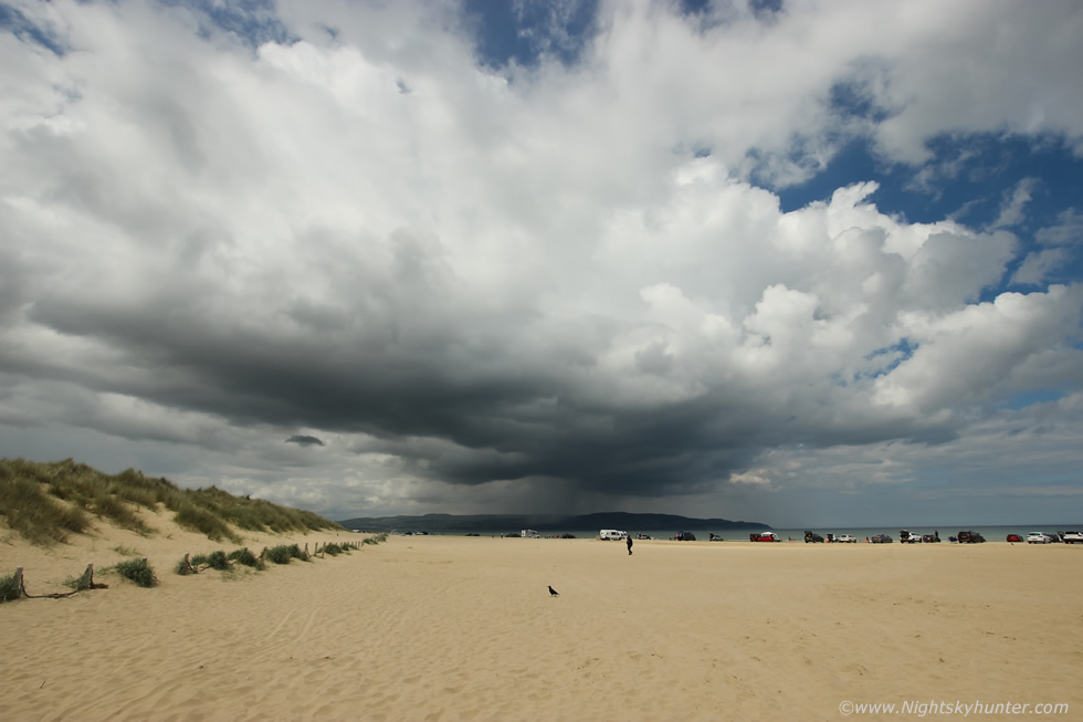 |
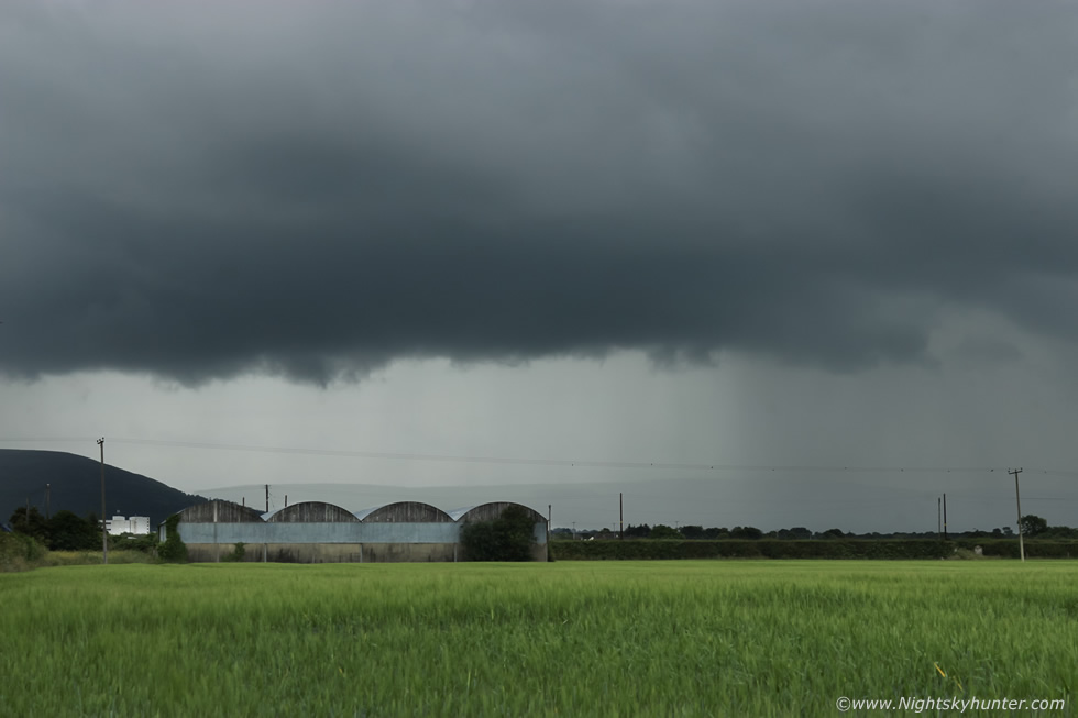
As we passed through Maghera I could see numerous clear sectors with blue skies and crisp white towering cumulus already growing and I began to get a good feeling. Roisin, Rhua and I stopped off at Benone beach first and had a much needed drink from the Sea Shed cafe then sat down within the sand dunes to take in the view. It was after midday and the sun was shinning, it actually felt stifling in the dunes, this was beyond what I had expected, I said to Roisin I had a good feeling about this day and had an instinct that something was going to happen. I got a text from Nigel McFarland reporting first c-g of the day in Co. Armagh, unreal there where storms inland already and soon after another text about a thunderstorm over Cookstown where we had left earlier, it sounded like it was all kicking off inland. I remained patient and decided to stay cool and wait it out, I knew our target area was good. Meanwhile convection was bubbling up in earnest all around us, this cell rapidly developed over the sea between Benone and Donegal and to me it looked like it was trying to form into a storm. This was 10mm wide angle on the 600D.
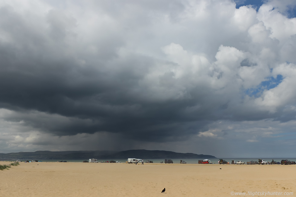 |
I switched over lenses for a closer look at the base, the breeze from the downdraught caused sand to blow across beach in large puffs between me and the cell which was cool to watch. We then drove around to Magilligan Point for a change of scenery, as soon as we parked the sky went from blue skies to rain in an instant, there seemed to be one shower passing over us which looked light, then suddenly it got stronger and stronger and intensified into a dramatic core with complete torrential rain, the sound of the large raindrops on the van roof was loud, the precip hammered us for 20 min's, we couldn't believe how strong it was and how rapidly it had developed.
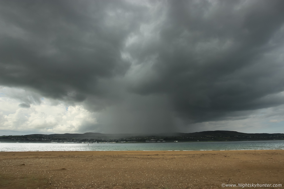 |
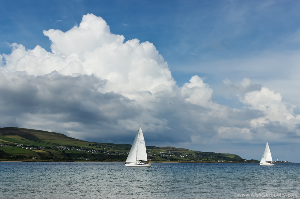
Once it passed over we headed down to the beach, this was the back end of the cell at 10mm with that core now hammering Greencastle and Donegal. Nigel McFarland arrived on the beach to check out the sky then we heard thunder, it came from that very same cell passing over Donegal. Then to our left was a line of cells crossing the far end of the lough and they too were rumbling with thunder, now we had two active thunderstorms, we were all buzzing, it's hard to beat hearing thunder from the beach. Colleen Webb also joined us so now all four of us did a sky watch from this beautiful vantage point, over the course of the next 30 min's we heard regular distant thunder from both these storms.
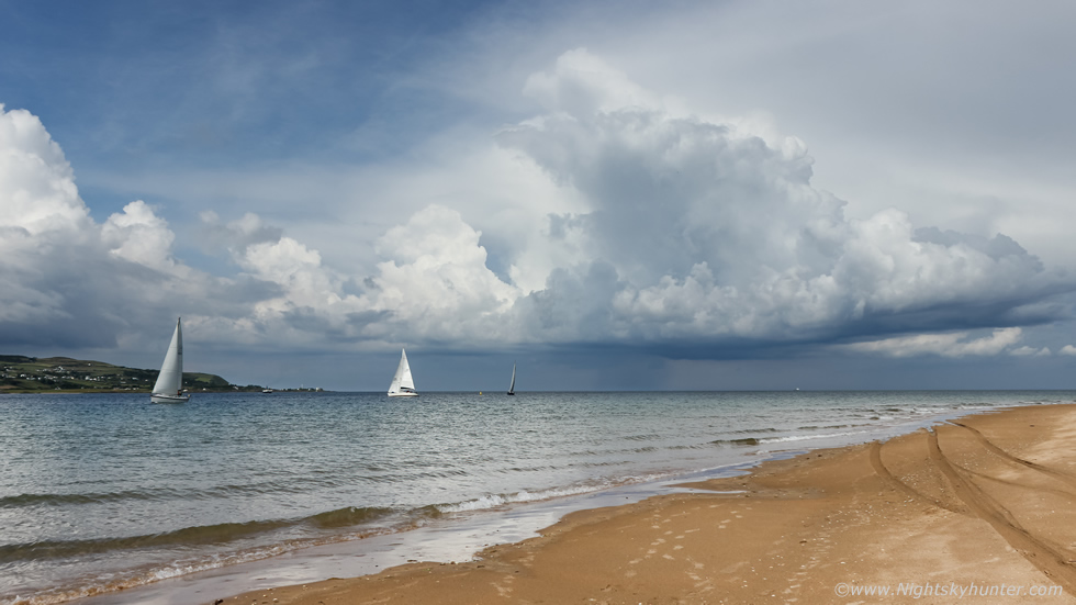 |
We spent a long time at Magilligan Point monitoring convection and enjoying the weather, it was very warm on the beach so we all chatted and chilled out while keeping an eye on radar. Paul Martin text me from Omagh saying he was getting plenty of lightning so storms were still erupting inland, we decided to hang out here and wait for developments to move north later. New towers began to go up over the ocean, I didn't have my tripod to hand so Colleen lent me hers which was very nice of her, so I shot a time lapse of these towers slowly building over the sea off the Donegal coast. We all watched and hoped for a funnel cloud or waterspout. Sail boats entering the Lough added to the tranquil beauty of the area.
 |
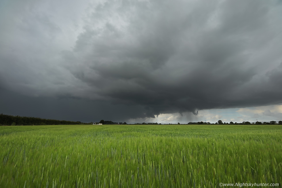
The radar was an impressive scene with countless showers and thunderstorms across the midlands aligned S to N/NW all with red cores, the charts were covered with lightning plots, this was turning out to be the most active storm day of 2021, we were all shocked as there was no shear at all, we figured the CAPE values must have been much higher than modeled and the storms must have been feeding from the low level moisture which had pooled over the country during the last two days, the intense solar heating really helped with lift and judging by the repeating cell alignments its likely that surface convergence was also aiding with lift also.
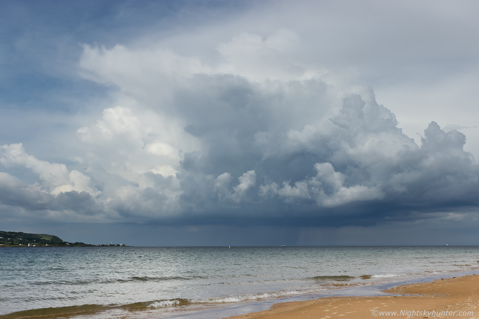 |
No waterspouts but believe it or not this was actually a storm, Colleen showed me a single c-g lightning plot from the core on ATD sferics. Watching convection and storms building over the sea on a hot day reminds me a little of Florida, actually that big white tower at centre on the other side was the updraught which produced the lightning. I got a time lapse sequence of this cell moving R to L across the entrance to the Foyle.
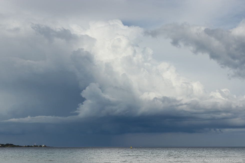 |
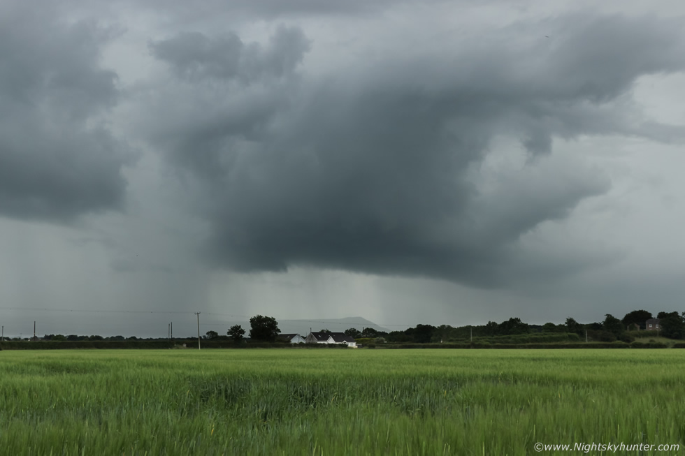
Quite a nice base with stair-step updraught pattern on the flanking area, that's Shrove Lighthouse to the lower left in Donegal. Behind us was a massive line of cells approaching with numerous sunlit towers along the leading edge, they were slow moving but coming our way, radar indicated they were shifting more NW in accordance with the GFS surface flow changing at this time so we could end up missing them. At the far end of the lough another cell was brewing with a pileus cap on top, a sure sign of vigorous updraught activity and sure enough it wasn't long before the updraught lifted the pileus and punched through. We were roasting on the beach, my back was burning and we all needed a drink so we decided to head back to the vehicles. We had a new plan, head a little further west and intercept that huge line of cells moving NW.
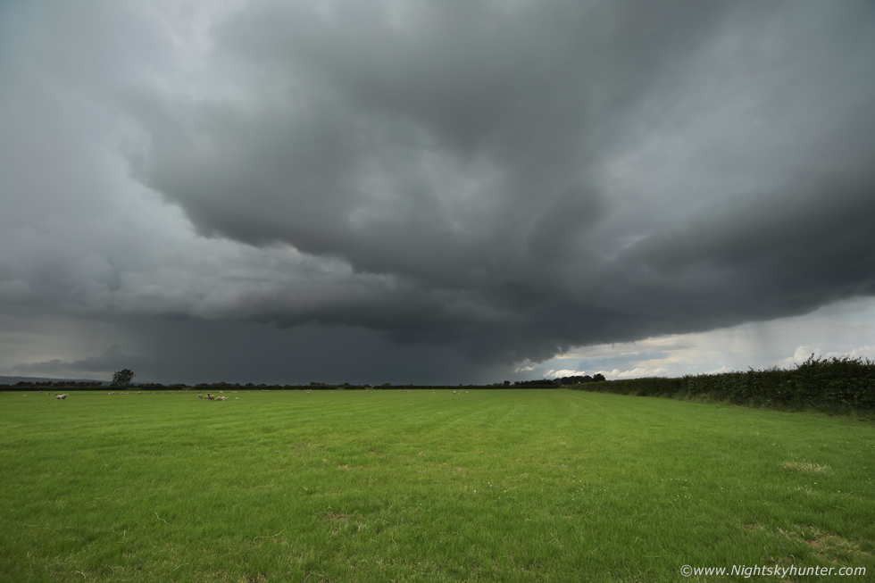 |
All three of our vehicles headed west to intercept, Nigel led the way as he knew the area better than we did, through the windscreen we could see black storm clouds and a heavy core of rain crossing in front of us, Roisin seen a bolt of lightning light up the precip, we where on our storm already. I so badly wanted to pull over and get an image of the scene but we where on twisting country roads with nowhere to pull over with traffic behind us, I sent a mental image to Nigel to find us some place which offered a good view, he was either reading my mind or thinking the very same thing himself because he took an adjacent road deeper into the countryside surrounded by flatlands and farmland, we pulled over at the side of the road for a look. We where surrounded by huge fields to choose from, I grabbed the camera and jumped over a gate into the field to my left.
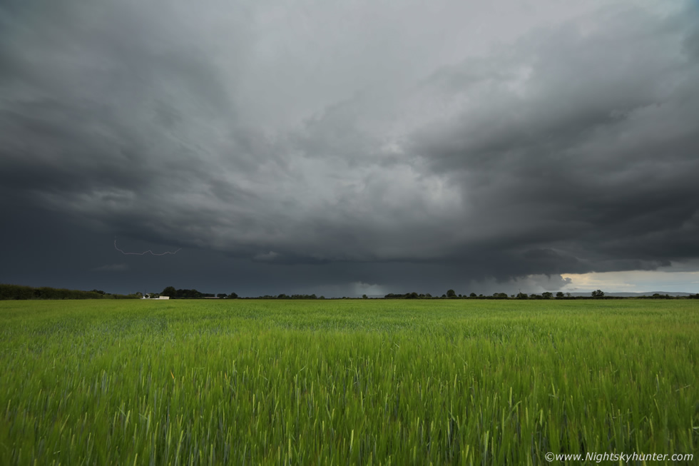
This is 15mm wide angle on full frame, thunder rumbled, the storm was moving slowly from left to right. To the right, out of frame, a very dramatic lowering formed under the base, it began as scud then began to tighten and solidify, at the same time it began lifting at an alarming speed upward, we all watched with excitement, we were expecting a funnel at any moment.
 |
I jumped back over the gate and onto the road ready to grab my other camera with the longer lens but the the lowering turned back to scud. What we had seen was outflow near the core forcing air aloft agitating the scud lowering which had generated our mad dash to the cameras. This was the scene from the middle of the road, Colleen's car on to the left and Nigel's van on the right.
 |
We all made our way into the next field on the right, Roisin and Rhua joined us so we all enjoyed this thunderstorm together. The storm rumbled on a regular basis and produced in-cloud bolts which had us yelling with excitement, I also spotted a c-g strike down behind that white house, we were now witnessing more lightning in the last few minutes than we had all year. I had the 5D Mark IV set up on the tripod and began shooting a wide angle time lapse, I have to say I was absolutely loving this moment, watching a mean storm over this wheat field in Myroe, this was the N. Ireland version of Kansas. Colleen was shooting a time lapse, so was Nigel with his DJI Osmo and Roisin was shooting stills and video with her phone. Rhua was a little nervous with all the thunder so we took turns holding her and to let her know she was fine and that his was a 'fun thing'.
 |
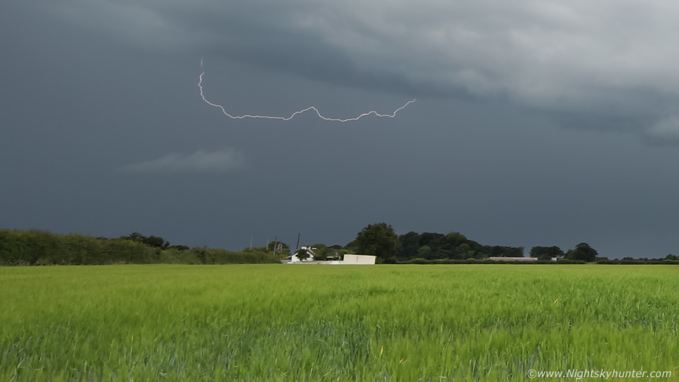
The storm was in the process of crossing over Lough Foyle and moving north. We watched a bright in-cloud bolt lash across the core which got us cheering, Roisin got it on video while filming a vlog. Turns out I captured it on a still image while shooting a time lapse, please keep in mind the bolt was brighter and much larger in reality, this is a super wide angle lens which takes in a massive view of the sky so things tend to look smaller and further away than they really are.
 |
Deep crop with image slightly brightened, technically this is the first daytime bolt I have captured shooting time lapse so I was well pleased with this lucky catch, pity the camera didn't catch that c-g in the same spot. Suddenly we heard more thunder, this time behind us, two more storms were approaching so we now had three storms in the area.
 |
We ventured into another field facing back inland towards this new line extending across the Sperrins to Binevenagh and within the line where two active thunderstorms. We observed sporadic flashes and rumbles from both cells, these were storms number four and five. I left the 5D shooting a time lapse, we all chatted for a bit while enjoying the thunder and by pure chance we all happened to glance in this direction and witnessed a terrific lightning bolt!, this didn't come from the precip core or the storm base, it came down from high above through the mid level cloud and struck the ground at the other end of the field behind a farm building, to me this bolt looked brilliant silver and electric blue, Roisin observed purple.
I decided this had to have been a positive bolt for it came from the top of the storm to the surface, these are more rare than typical c-gs and are very destructive and dangerous. This bolt was spectacular but also made us feel vulnerable, it was too close for comfort and we began thinking about our safety. We all knelt down low, the only thing taller than us was the telegraph poles and that wasn't by much and what was disconcerting was that there were no telegraph poles where we had parked among these flat fields. I set up the 600D with 18-55mm and began a second time lapse facing the area of the strike incase of more. Amazingly my wide angle time lapse never captured that amazing bolt, what a scene that would have been, it must have struck between frames as I was shooting one second intervals. The above image is the area close to the positive strike at 35mm showing the dark storm base and core over a row of barns, storm moving right to left and towards the camera.
 |
Colleen and I witnessed two more silver-blue c-gs strike behind that dark tree one after the other in rapid succession but yet again the cameras never caught them. If the light had been lower to generate a slightly longer shutter of say 1-2 seconds I'm sure I would have captured all these bolts. Another solution would have been to use a grad filter to darken the sky to get the longer shutter but I don't own any filters, I have never used them in my life and likely never will. Another alternative would be a lightning trigger, however those are expensive.
Reports came in on social media of a lightning bolt striking a coffin making shop in Strabane which caused a huge explosion and fire which was very dramatic, we couldn't believe the images we were seeing online, this wasn't the kind of stuff you would expect to happen in N. Ireland, it just goes to show how powerful these storms were and how to never under estimate storm set-ups which lack shear when you have good instability and humidity to compensate. Then more reports came in of heavy rainfall and flooding in Portstewart which ripped away tarmac damaging the main seaside road with large holes, I have to say these have been the most damaging pulse type thunderstorms I've ever experienced. As the storms suddenly went quiet, we stayed low, packed away the gear and headed home well satisfied and ready for a good dinner. This was a very unexpected chase day which went from grey soup and no storms to prolific storms with damaging lightning and flooding all day long, it just goes to show that nature will do what she wants no matter what the models say.
 |
This is a bit random, a few days earlier I saw a dramatic image on twitter of dense fly swarms near Lough Neagh, these swarms were of 'flynadoes' like dark funnels perched over tree tops and even coming off the ground itself, they looked impressive. The last time I saw these was during 2008 when I captured many images from Ballyronan Marina, I actually had a website report at the time which I had since deleted. I went again for a look on a day of downtime and ended up in Ardboe, there wasn't much happening but suddenly towards late afternoon as the breeze settled down they appeared, however the scene was nowhere near as dramatic as the image I had seen the day before, this was all I got, I may try this again when conditions become more favorable.
Time lapse video of the ocean convection and Myroe thunderstorms, this is made from over 5000 images with two DSLRs using 18-55mm and 15mm lenses. I added in the audio over the footage which I got online in an attempt to capture the atmosphere with the clouds. Thanks very much for watching.
Martin McKenna
